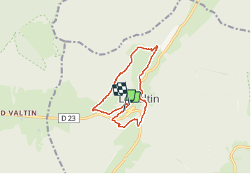
LES ROCHES DU VALTIN

surceneux
User

Length
6.2 km

Max alt
1026 m

Uphill gradient
388 m
Km-Effort
11.4 km

Min alt
736 m

Downhill gradient
400 m
Boucle
Yes
Creation date :
2020-09-12 13:22:05.074
Updated on :
2020-09-12 17:43:37.055
2h00
Difficulty : Medium

FREE GPS app for hiking
 SityTrail
IGN / Geographical institutes
SityTrail Plus
The world is yours!
About
Trail Walking of 6.2 km to be discovered at Grand Est, Vosges, Le Valtin. This trail is proposed by surceneux.
Description
DEPUIS LA MAIRIE DU VALTIN DISQUE JAUNE PUIS ANNEAU VERT DIRECTION HTES NAVIERES, SUIVRE LA MEURTHE JUSQU'AU VILLAGE- D23 SUR 300M- TRIANGLE ROUGE ET RETOUR AU VILLAGE VIA LE RAMBACH
Positioning
Country:
France
Region :
Grand Est
Department/Province :
Vosges
Municipality :
Le Valtin
Location:
Unknown
Start:(Dec)
Start:(UTM)
352573 ; 5328895 (32U) N.
Comments